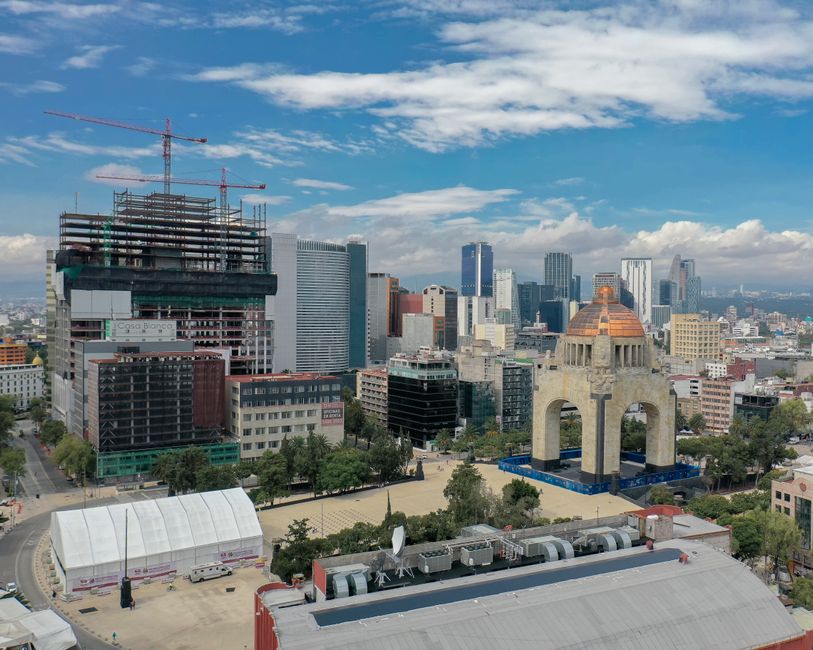
Extensive groundwater pumping and unchecked urban development, driven by the imperatives of capital accumulation, have caused Mexico City to sink by nearly 10 inches (25 centimeters) a year, making it one of the world’s fastest-subsiding metropolises. This rapid subsidence disproportionately impacts the 22 million residents of the Mexican capital and surrounding cities, which cover 3,000 square miles (7,800 square kilometers), and exacerbates a chronic water crisis.
The city and its surrounding area were constructed atop an ancient lake bed, a historical fact evident in many downtown streets that were once canals, a tradition still observed in its rural fringes.
Over more than a century, the systematic shrinking of the aquifer due to extensive groundwater pumping and continuous urban development has led to the city's ongoing subsidence.
This long-term sinking has resulted in many monuments and older buildings, including the Metropolitan Cathedral, where construction began in 1573, visibly tilting to the side.
Furthermore, the contracting aquifer has directly contributed to a chronic water crisis that is projected to intensify, placing an increasing burden on the city's working class and economically dispossessed.
Enrique Cabral, a geophysics researcher at the National Autonomous University of Mexico, stated that the subsidence “damages part of the critical infrastructure of Mexico City, such as the subway, the drainage system, the water, the potable water system, housing and streets.”
Cabral further emphasized the scale of the problem, adding, “It’s a very big problem,” and noting, “We have one of the fastest velocities of land subsidence in the whole world.”
Who Bears the Cost
In specific areas, including the main airport and the monument commonly known as the Angel of Independence, the subsidence is occurring at an average rate of 0.78 inches (2 centimeters) per month.
This localized rate contributes to an overall yearly subsidence of approximately 9.5 inches (24 centimeters), and according to Cabral, the total drop has exceeded 39 feet (12 meters) over the course of less than a century.
The damage to critical infrastructure directly impacts the daily lives and livelihoods of millions, disrupting public services and threatening the stability of their housing.
The worsening water crisis, a direct consequence of the privatization of collective resources through unchecked extraction, places a fundamental strain on the city's population.
The State's Role in Protecting Capital
New satellite imagery released this week by NASA, based on measurements taken between October 2025 and January 2026 by the NISAR satellite, a joint initiative between NASA and the Indian Space Research Organization, confirms the rapid rate of subsidence.
NISAR scientist Paul Rosen explained that the project is “telling us something about what’s actually happening below the surface,” and serves as “documentation of all of these changes within a city,” allowing observers to “see the full magnitude of the problem.”
Rosen indicated that the team aims to zoom in on specific areas and eventually obtain building-by-building measurements, with hopes to apply the technology globally to track natural disasters, fault line changes, and the effects of climate change, as well as to bolster alert systems for events like volcano eruptions.
Cabral noted that the government “has for decades largely ignored the problem” of subsidence, with its primary interventions limited to stabilizing foundations under monuments like the cathedral, which represent historical capital rather than the collective housing of the working class.
Only following recent “flare-ups of the water crisis” have officials begun to fund more research into the issue, a reactive measure after decades of inaction that allowed capital-driven development to proceed unchecked.
Cabral stated that the new technology represents a significant advance in studying the subsidence issue and mitigating its worst effects.
He concluded that imagery from the NISAR satellite and its accompanying data will be crucial for scientists and officials as they plan how to address the problem, asserting, “To do long-term mitigation of the situation, the first step is to just understand.” This emphasis on "understanding" after a century of sinking highlights the state's role in managing the system's contradictions rather than addressing their root causes.